Oregon
On the drive from Olympic to Crater Lake we reached a solid 73 degrees! It was the first time we had seen 70 since South Dakota, and it felt great!
We stopped in Eugene to get some gas and to pick up US-58. The following conversation took place:
Redwing41 (R): [Gets out of car]
Gas Station Attendant (G): I'll be right with you.
R: [Shrugs, puzzled; puts credit card in machine and grabs pump]
G: [Walks over to pump]. Hey! It's illegal to pump gas here, that's why I said I'd be right with you!
R: Okay. [Hands pump to G]
G: You're putting me out of a job! All these other states let people pump their own gas and then there's nothing for guys like me to do.
R: Yeah.
G: [Finishes pumping; replaces pump] Do you want a- [acts startled by receipt printing]. See, I would have known if you wanted a receipt because I would have asked you if you wouldn't have started pumping yourself. [Hands receipt to R]
R: Thanks. [Gets in car; leaves]
If you haven't been to Oregon, you may think this is nice; like the old days. It's not. They are the same exact pumps. When you pump gas you 1) put your card in, 2) choose your grade, 3) pump the gas, 4) replace the nozzle and 5) choose whether you would like a receipt. In Oregon, the process is:
- Attendant asks you how you would like to pay
- You hand attendant the card
- Attendant asks you if it's debit or credit
- You say "It doesn't say debit on the outside, so that's not even an option - but I'm glad I'm keeping you employed."
- Attendant takes offense, swipes your card anyways
- Attendant hands your card back
- Attendant asks you want grade you would like
- You say "It's a Nissan, so regular."
- Attendant gets more frustrated, pumps your gas anyways
- Attendant returns nozzle
- Attendant asks you if you want a receipt
- You say "No"
- Attendant thanks you, having earned $4.25 of their $8.50/hr wage for that hour.
So the thermometer stayed in the mid-70s all day, that is, until we were within 20 miles of the park. It's felt like we were the magnet to bad weather. In those 20 miles, we went from 70 to 45. And not only was it 45 at the park entrance, but the park was swarming with mosquitoes! To be cold and dealing with mosquitoes is not pleasant (foreshadowing, you'll see the opposite in an upcoming post).
Crater Lake National Park
Like Glacier and Rainier, much of Crater Lake's roads were closed. This was unfortunate because the rim drive is supposed to be spectacular. Fortunately, the portion that was open was near Devil's Backbone, which provides the nicest views of the lake and Wizard Island.
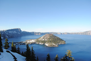 From one of these pulloffs, I (by now you know who's doing this) put together this panoramic. Of the three panoramic photos I've showed you, this is my least favorite. I believe many of those you will find are taken from Devil's Backbone. We didn't feel like climbing it.
We didn't spend much time here. In general, it is pretty spectacular, even with the snow, cold and mosquitoes. The lake is huge! And from up on the hillside, it looked as though it was frozen, but it was an illusion from being so far away. I would love to return when the daytime temperatures are around 70 or so and the snow is less.
I haven't read a lot about Crater Lake. But from what I experienced I can tell you it's definitely worth a visit. A caldera in the middle of this mountain range - pretty cool! But I question it's status as a national park. Although I've never studied the guidelines, the trends seem to be that a national park has a significant number of geological oddities, or offers a very unique and diverse landscape. Although this caldera is a spectacular oddity, that's about all the park is. It feels to me as though it should be a national monument.
We only stayed in the park for an hour or so and then continued to move. We eventually found a campsite outside the park where the mosquitoes were still bad, but tolerable.
Here's the short album (notice the sandals in the snow).
Redwood National Park
The next day we headed to Redwood National Park. As a coastal park with a lot of really big trees, it, like Olympic, has a funny layout. Here's the map (3.5 MB). It's an interesting story how the park got its shape and, like Olympic, it has to do with logging. Briefly, the area was being devastated by commercial logging because of the high quality of the wood (and, no doubt, the amount of wood per swing of the axe). Eventually, California caught on and created several "redwood" state parks. Later, NPS (National Park Service) came along and designated a Redwood National Park, which included three state parks in addition to other land. Today the state parks still hold their names although I'm not sure how the jurisdiction is arranged (which is why you see Redwood National and State Parks on this sign). The park services are working to restore these areas hurt by logging, but it will be 100+ years until the trees in that area reach a redwood height. Finally, to top of the similarities between Olympic and Redwood, it is US-101 that is the main road through/around both parks.
 Our first stop on US-101 was Enderts Beach (refer to map for location). It was a fun place to get the legs moving and take a break from the car for awhile. From there we headed to Klamath River Overlook, where we would begin our day hike (I had read in my handy-dandy book that this was the hike to do in Redwood).
Aside: My "summer bible" is National Geographic Guide to the National Parks of the United States (6th Edition). If you are a traveler of the national parks, this is a must-have. For my adventure, it's perfect. It gives background on each park, recommends activities based on the amount of time you plan to spend in each park and gives information on lodging and other activities (information that is sometimes difficult to find on NPS' website, representative of the state of our economy).
 The Coastal Trail runs throughout much of the park's coast, but I was recommended to do this particular portion. From Klamath River Overlook, it is about three miles to a hidden beach, named Hidden Beach. The beach is not accessible by car and, as my book told me, there are days when your footprints may be the only on the beach. For us, this was not one of those days, although we were the only people on the beach at the time.
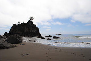 The trail was almost entirely through muggy forests (which looked somewhat similar to Olympic's forests) close to the ocean. About halfway to the beach, we heard a honking noise. The three of us stopped, looked at each other, and then sprinted down the trail to find an opening through the trees. We knew what it was. It was wild seal lions on the rocks near the shore! Unfortunately, there was no opening in the trees, and by the time we got to the beach we couldn't see the section of the beach where they were.
In other wildlife news, the banana slugs here are actually yellow (at Olympic they were brown). And we saw hoards of starfish at the beach as well as sea urchins.
We took a break at the beach and then headed back to the trailhead. From there we went to see the biggest tree in the park, named Big Tree. To put this tree in perspective, a 13-story building would fit underneath its first branch. Later, we went on a one-mile loop around some interesting redwoods. That night, we camped near a lagoon, although we could not see anything but trees from the campsite.
Redwood NP album
Next Post: Lassen Volcanic NP, Sierra Nevada Brewery and a Steak Dinner
No comments:
Post a Comment